































Table of Contents
- Key Points
- Understanding Collaborative Perception
- Sparse 3D Gaussian Sharing: A Novel Approach
- How does this system generate 3D gaussian
- Pricing
- Advantages and Disadvantages of 3D Gaussian Sharing
- Core Features
- Use Cases
- FAQ
- Related Questions


Understanding Collaborative Perception
The Foundation of Collaborative Perception
Collaborative perception centers around the concept of multiple agents sharing and integrating their perceptual data.
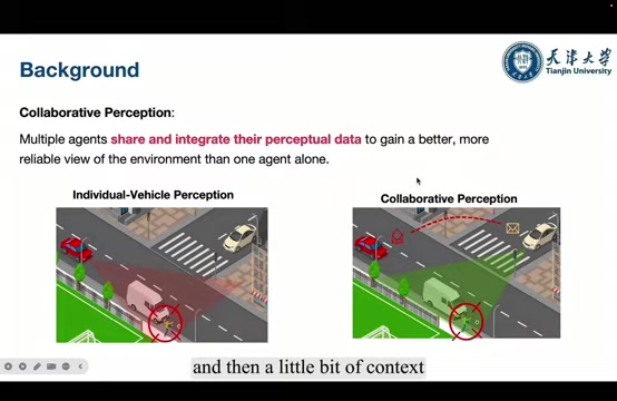
This synergistic approach aims to create a more accurate and reliable view of the environment compared to relying on a single agent's observations. In the context of autonomous vehicles, this means vehicles equipped with sensors like cameras, LiDAR, and radar exchange information with each other. By combining these diverse data streams, the system can overcome individual limitations and build a more complete picture of the surroundings.
Imagine a scenario where one vehicle's view is obstructed by a large truck. A neighboring vehicle, with a clear line of sight, can share its data to fill in the missing information. This collaborative effort is the core of improved safety and efficiency. This sharing isn't just about raw data; it often involves processed information such as object detections, semantic segmentations, and predicted trajectories.
Communication bandwidth and latency present major hurdles for this paradigm. Transmitting large volumes of sensor data in real-time is challenging, particularly in environments with limited network connectivity. Furthermore, errors in vehicle positioning can lead to misalignment of shared data, degrading the accuracy of the fused perception. Therefore, effective collaborative perception strategies must address these challenges to maximize their potential.
Challenges in Existing Multi-Vehicle Systems
Existing multi-vehicle collaborative perception systems face several key challenges that limit their widespread adoption. These include:
- Trade-off between communication bandwidth and performance:
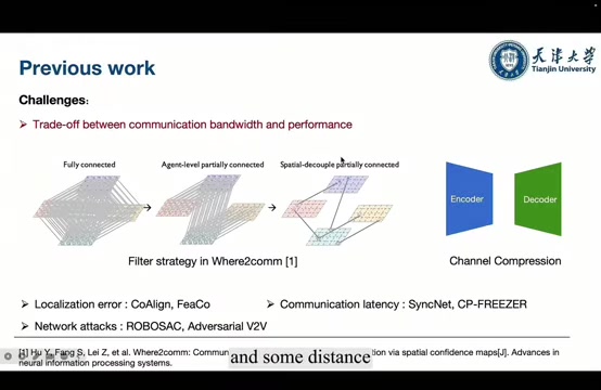
Increasing the amount of shared data generally leads to improved perception accuracy, but it also strains communication bandwidth. Finding the optimal balance between these two factors is a crucial design consideration.
- Localization and positioning errors: Inaccurate vehicle positioning can lead to misalignment of shared data. Errors can arise from GPS inaccuracies, sensor calibration issues, or environmental factors.
- Communication latency: The time it takes to transmit and receive data between vehicles can impact real-time performance. High latency can render shared information stale, making it less useful for decision-making.
- Network security attacks: Collaborative perception systems are vulnerable to network attacks where malicious actors inject false data or intercept communications. Robust security measures are needed to prevent compromised data from impacting the system's integrity.
Research efforts are focused on addressing these challenges through innovative techniques such as data compression, selective data sharing, robust data fusion algorithms, and secure communication protocols. Techniques like channel compression and advanced filter strategies (as seen in Where2comm) aim to minimize bandwidth usage and the impact of localization errors, paving the way for more practical and reliable collaborative driving systems.
Sparse 3D Gaussian Sharing: A Novel Approach
Introducing Sparse 3D Gaussian Sharing
This blog post highlights a communication-efficient multi-vehicle collaborative semantic segmentation approach leveraging sparse 3D Gaussian sharing.
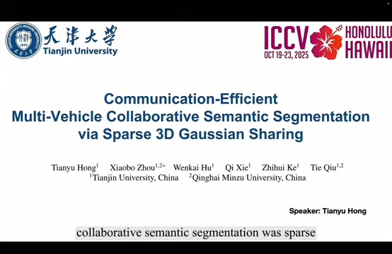
Unlike traditional methods that directly share dense sensor data, this technique focuses on transmitting a compact representation of the environment using 3D Gaussians. This innovative approach significantly reduces the communication overhead while preserving essential spatial information.
3D Gaussians provide a discrete spatial representation that is particularly well-suited for filtering and redundancy removal. Each Gaussian represents a localized region in 3D space, characterized by its position, orientation, and covariance. By selectively sharing these Gaussians, vehicles can communicate critical information about their surroundings without overwhelming the network with unnecessary data.
This approach addresses the core challenges of multi-vehicle collaborative perception:
- Communication Efficiency: By sharing sparse 3D Gaussian representations, the amount of data transmitted is significantly reduced compared to sharing raw sensor data or dense feature maps.
- Robustness to Positioning Errors: The Gaussian representation is inherently robust to small positioning errors, as slight misalignments in vehicle positions do not drastically alter the overall spatial representation.
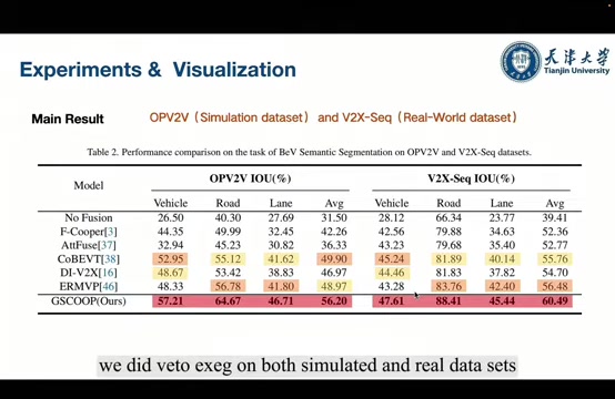
- Semantic Segmentation Accuracy: The shared 3D Gaussian representation provides sufficient information to enable accurate semantic segmentation, allowing vehicles to identify and classify objects in their environment.
3D Gaussian Representations for Improved Performance
Why 3D Gaussians? The choice of 3D Gaussians is strategic, offering several advantages over other representation schemes:
-
Discreet Representation: 3D Gaussians provide an accurate discrete spatial representation, lending to ease of traffic management.
-
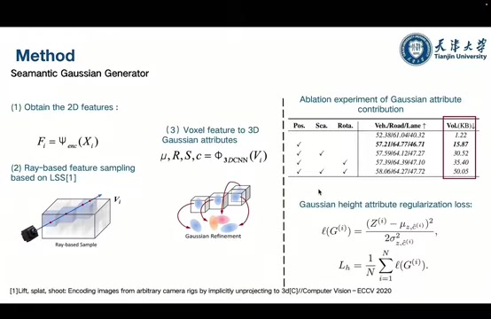
Height Information: Unlike BEV (Bird's Eye View) features, Gaussians inherently capture height information, vital for accurate scene understanding and feature fusion. The BEV approach lacks display height information, making feature fusion more difficult.
-
Spatial Representation: Gaussians create a valuable visual of the surrounding space. Sharing each vehicle creates an ecosystem of information.
-
Efficiency: The discrete elements of the 3D Gaussian representation means filtering can easily be preformed, and any redundancies easily eliminated.
In short, by leveraging 3D Gaussians, the system can achieve the benefits of collaborative perception. Vehicles sharing the same visual cues reinforces the data's integrity and accuracy.
Core Features
GSCOOP Capabilities
At its core, the GSCOOP system performs three crucial steps to deliver superior performance.
- Semantic Generation: The Semantic Gaussian Generator Module does the bulk of the heavy lifting, producing highly complex and accurate visualisations. It leverages the Multi-View features from each vehicle's camera to generate a robust environmental picture.
- Filtering and Compression: Filtering and compression is performed on the visualisation to reduce and noise or useless artifacts. By increasing the bandwidth, processing becomes much more efficient.
- Rasterization: The scene is re-rendered as a 'Bird's Eye' visualization. The is then semantically rendered to allow operators a clear, easy-to-read report.







Most people like






























Report
Please select a reason for reporting
- 13 Reasons to Switch from Snapchat to Text Messaging
- 7 Powerful Speech to Text Apps to Boost Productivity
- 10 Best Speech to Text Tools for Effortless Transcription
- 13 Free Tools to Easily Transcribe Audio to Text
- 15 Surprising Ways Google's Speech-to-Text Boosts Productivity
- 7 Best Free Online Audio to Text Transcription Tools
- 9 Tips to Transcribe Speech to Text Faster and Better
- 13 Best Speech to Text Software for Windows 10 in 2023
- 7 Tips for Choosing the Best Transcriber for Audio to Text
- 11 Reasons Why Dragon Speech-to-Text Apps are Game-Changers
- 6 Secrets to Enhance Your Speech to Text Transcription
- 6 Brilliant Ways to Boost Productivity with Talk-to-Text on Your MacBook
- 6 Ways Transcription Software Converts Audio to Text
- 8 Tips to Transcribe Speech to Text Like a Pro
- 6 Reasons IBM Watson Speech to Text is a Game-Changer
- 14 Powerful Ways Talk-to-Text Improves Your Workflow
- 12 Top Windows Speech-to-Text Software for Efficient Transcription
- 12 Game-Changing Benefits of Apple's Speech to Text Technology
- 9 Powerful Use Cases for AWS Speech to Text Technology
- 10 Easy Steps to Transcribe YouTube Videos to Text
- transcription audio en texte
- online audio transcription
- free audio file transcription
- free ai audio transcription
- audio transcription service
- audio transcription online free
- audio transcription free online
- audio to transcription software
- audio and transcript
- ai audio transcription free
- voice recording to text converter
- translate voice recording to text
- record voice to text
- audio recording to text converter
- voice recording and transcription
- chatgpt voice to text
- gmail voice to text
- speech to text reader
- speech to text ai free
- speech to talk
- Revolutionizing Storytelling: From Novels to Screenplays with AI
- Create Engaging Animated Explainer Videos with a Free AI Tool
- Stop Multi-Subscribing: Benchmark Top AI Visual Models in One Canvas
- Best Seedance 2.5 API Provider: Every Price on the Market, Checked at Source
- AI OnlyFans: How to Generate $30,000/Month (Legally)
- Transform Your Script into an Engaging Video with AI Video Maker!
- AI Marketing Automation: A Comprehensive Guide for Small Businesses
- Midjourney Alternative for Anime Art Creators: Why PixAI May Be Better for Character Workflows
- 10 Things Most People Get Wrong About AI Image Search
- AI Girlfriend Apps: Top Choices Redefining Relationships 2025
- Top 4 AI Platforms to Extend Video: The Ultimate Comparison for Creators
- Top 8 Best AI Image Editor Tools for Creative Professionals in 2026
- Experience the Future of Virtual Assistants with F.R.I.D.A.Y. AI
- Learn How to Train an AI to Play Snake with Reinforcement Learning
- Creating a Unique AI Game Environment with Pygame
- Mastering the Classic Java Snake Game
- Discover the Power of Codex: Snake Game Created in Python
- Building an AI to Master Snake Game
- Revolutionize the Classic Snake Game with AI
- Websim AI: Create Games and Apps with Just a Few Prompts

Copyright ©2026 toolify